Analysis
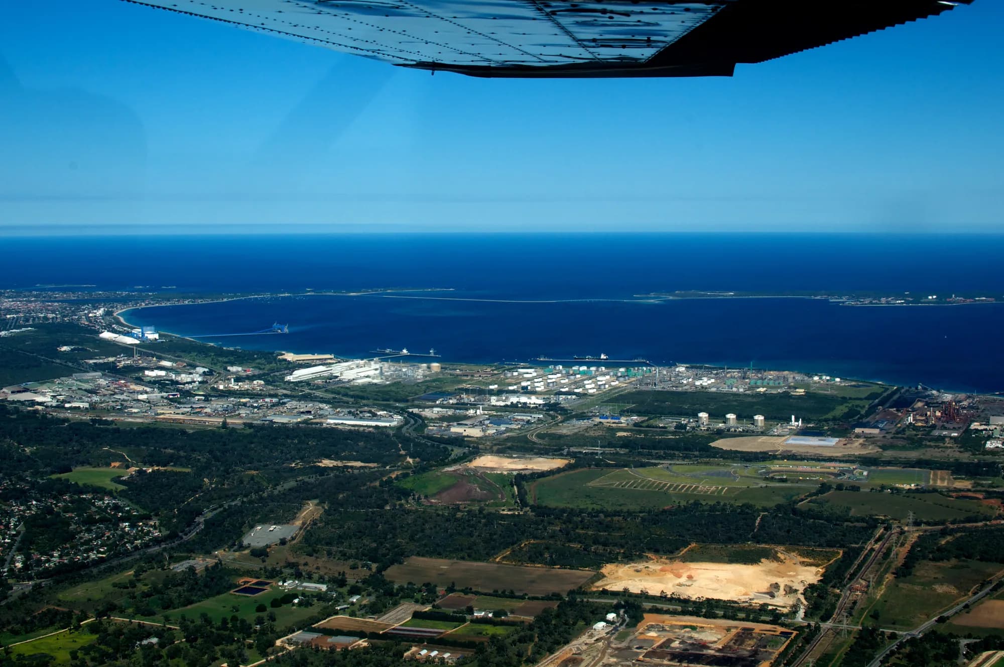
A Western Australian state MP and former Army intelligence officer has warned that Cockburn Sound, the water where United States and United Kingdom nuclear submarines are to rotate under AUKUS, has only one navigable way in or out, and that the state’s plan to move its container port into that water has not been weighed against the submarine base being expanded across from it.
Jonathan Huston, the independent member for Nedlands in the Western Australian Legislative Assembly, made the argument in a video posted to his verified Facebook page on the evening of Friday 11 September US Eastern time, Saturday morning in Perth. It drew a comment thread running to roughly ninety replies over the weekend.
Jonathan Huston's video, posted to his verified Facebook page, 11 September 2026.
Loads Facebook’s own player, nothing before you click. Or open it directly on Facebook.
What Huston Said
Huston walked through the chart of the Sound’s northern approach. Running west from Woodman Point toward Carnac Island is a sandbar he described as the former coastline of Western Australia. Across most of that crossing, he said, the water is about five meters deep, roughly 16 feet, too shallow for a ship or a submarine. The only way through, he said, is a cut roughly 157 meters wide, about 515 feet, and about 14 meters deep, about 46 feet.
“It’s a cork in the bottle at that point,” he said. A vessel inside the Sound when that route is blocked, he said, “is not going anywhere.”
He said the constraint explains the rising cost of Westport, the state project to move Western Australia’s container terminal from Fremantle to Kwinana. In his account, the project now requires a new 20-kilometer channel, about 12.4 miles, cut out at sea so that two channels can operate, and he invited viewers to consider the cost of building it.
On this point, Westport’s own federal filing goes further than the state’s public messaging does. Its referral to the Commonwealth under the Environment Protection and Biodiversity Conservation Act, lodged in 2024 as Outer Harbor Port Development, Kwinana, calls the existing Success Channel the sole channel currently providing large vessel access to Cockburn Sound from the north. It says the new channel will reduce operational risk and increase operational capacity by providing a second point of access into and out of the Sound.
Westport’s public account of the channel makes no mention of that. It gives the driver as the larger container vessels expected on the route in future, and says a new channel was preferred over widening the existing one because widening would have damaged more seagrass. The resilience rationale appears in the filing to the federal regulator and not on the website.
The referral puts the second main channel at approximately 21 kilometers long, about 13 miles, with a variable width between 250 and 470 meters including batters, roughly 820 to 1,540 feet. Its minimum design depth is 17.9 meters below chart datum, about 59 feet, deepening in places to 19.5 meters, about 64 feet. It would run from the northern boundary of Cockburn Sound out to the Indian Ocean, across Owen Anchorage and Gage Roads, with an indicative footprint of 626 hectares. Capital dredging for the project as a whole is estimated at up to 35 million cubic meters. Westport describes the design behind those numbers as preliminary, at 15 percent of total design effort.
Huston framed his concern as a question of sequencing rather than opposition to the port. “I’m not opposed to this, Westport, but I want you all to understand the geostrategic risks involved,” he said. Infrastructure built to last a century, he argued, and a nuclear submarine fleet built for the purpose of striking at a potential adversary, are being planned into the same water without anyone putting the two together.
The MP
Huston has represented Nedlands since 8 March 2025, according to the Parliament of Western Australia’s record of his parliamentary service. He took the seat from Labor with a two-party-preferred swing of 5.8 percent and holds it on a margin of about 2.7 percent, figures the ABC reported when he quit the Liberal Party in June 2026 to sit as an independent. He had been appointed opposition spokesperson for deregulation, small business, public sector reform and veterans in April 2025.
Before politics, he served in the Australian Army as an intelligence officer. His Liberal Party candidate biography records that he went from Aquinas College to the Royal Military College Duntroon, reached the rank of Major, and held postings in Canada and the United Kingdom. Writing under his own name for the Australian Strategic Policy Institute, he has described himself as a Duntroon graduate in the Australian Intelligence Corps.
That was not a one-off. In December 2020, he published an analysis of the Special Air Service Regiment in the institute’s journal The Strategist, in the wake of the Brereton inquiry into Australian conduct in Afghanistan. ASPI later ranked it the third most-read piece it published that year.
It is not his first intervention on AUKUS either. In October 2025 he wrote a paper criticizing the submarine agreement and circulated it to the media, prompting a public rebuke from Liberal leader Basil Zempilas, who told the ABC that was not the way to debate policy.
The Geography
The harbor authority’s own navigation guidance is more direct than anything in the video. Fremantle Ports states in its Port Information Guide, issued by the Harbor Master’s office for masters of seagoing vessels, that the Outer Harbor of the Port of Fremantle, meaning Cockburn Sound, can only be accessed via the Success and Parmelia Channels, which are entered from Gage Roads. It puts the two channel entrances at 32 degrees 05 minutes south and 32 degrees 07 minutes south, about two nautical miles apart, and gives both as designed to 14.7 meters, about 48 feet. Gage Roads, it notes, is open at all times to all classes of vessel. Owen Anchorage and Cockburn Sound are available only to vessels that can navigate those two channels. The largest ship the guide permits through them is 275 meters long with a 46-meter beam.
Westport’s referral says the same thing in its own words, describing the through route as a single narrow channel about 150 meters wide, roughly 492 feet, and approximately 15 meters deep, running through Parmelia Bank, Owen Anchorage and Success Bank, and calling it the sole channel providing large vessel access from the north.
Parmelia Bank is the crossing Huston describes, the southern of the two. A 2025 review of the Sound’s ecology, led by scientists at the Western Australian Fisheries and Marine Research Laboratories, the state government’s own research arm, with co-authors at Murdoch and Edith Cowan universities, and published in the peer-reviewed journal Frontiers in Marine Science, puts the two banks running from the mainland out to Carnac Island and Stragglers Rocks respectively, with deeper water of around 15 meters lying between and to the north of them at Owen Anchorage and Gage Roads. Western Australia’s Environmental Protection Authority, assessing a dredging proposal on Success Bank in the 1990s, recorded the seafloor there at 3 to 5 meters, about 10 to 16 feet, before industrial cutting began.
The constraint is long-standing. J. K. Ewers, in his history of Fremantle harbor, records that the Sound was barred to all but shallow-draft vessels by the two banks, that a channel was dredged through them during the First World War, that the work was abandoned in 1920, and that it resumed during the Second World War so naval vessels could use the anchorage. The Western Australian Museum’s maritime archaeology team, in its survey of the wartime defenses, confirms the work from Public Works Department plans, recording that expanding the Garden Island naval base meant dredging a shipping channel through the Parmelia and Success sandbanks and building barriers across the northern and southern entrances of the Sound.
Those barriers show how the last generation of planners read the same water. The museum survey puts the northern approach defense at 9,370 meters, about 5.8 miles, in one continuous line from Second Head on Garden Island to the northern side of Woodman Point, following the southern edge of the Parmelia Bank shallows. Anti-submarine netting was hung from timber dolphins driven into the seabed. Where the shipping channel cut the line, the plans left a 1,200-foot gap between two fourteen-pile gate dolphins for a boom gate to swing in, with a separate turning-back dolphin built to hold that gate open.
The gate was never fitted. In December 1944, the survey records show that Admiral Lord Fraser inspected the defenses, judged that Japan was by then on the defensive and that they would not be needed, and the gate was canceled along with other planned works. The design intent survives in the plans regardless. The last time Australia expected a naval threat in this water, defense planners treated the crossing as one gate to be held, and built nine kilometers of barrier around it.
Reaction
Commenters on the post repeatedly reached for the same historical comparison. “Think of AUKUS naval base then compare the risk of blockage to that of WW2 Pearl Harbor,” wrote Les L. Hayden. S. asked whether the problem had been identified long ago, writing: “Wasn’t the issue of a single channel recognized many years ago as it makes the naval base extra vulnerable?”
Mitch S. wrote that with a fleet of deep-keeled assets “you are trapped, while adversaries can simply deploy lightweight drones or missiles,” and said the single crossing to Garden Island would itself be an early target. Access to the base is by causeway from the mainland at the southern end of the Sound. Graeme D. disagreed on consequences, suggesting that at the first sign of tension “all functional craft will leave port and not be at risk of being trapped.”
Fergus B. posted a detailed objection to the basing decision, citing shallow water transit through what he called “a commercial shipping chokepoint,” radioactive waste accumulating at HMAS Stirling with no permanent disposal solution identified, and deep water submarine canyons off Albany and Bremer that he said were never evaluated as alternatives.
A separate cluster of replies raised fisheries rather than defense, contrasting the dredging plan with current restrictions on recreational fishing. “We’re cool to tear up a 20km long channel in the spawning grounds?” wrote Shane A. Glenn. S. said the channel would “decimate the only Pink Snapper breeding area outside Shark Bay,” a characterization this article has not independently verified. Others proposed alternative locations for the port or the base, including Albany, Bunbury, Exmouth and Darwin.
Several commenters remarked on the source rather than the substance. “Not some left-wing greenie,” wrote Jay G.
Disputed Points
Not all responses accepted the premise, and one objection turns out to be better supported than either the thread or an early draft of this article allowed.
Mark H. wrote that Cockburn Cement has been dredging a second channel for the port authority, that it sits roughly 900 meters east of the existing channel, that it is close to finished, and that it has not cost the taxpayer anything. The public record supports more of this than it contradicts, though the timeline runs longer than he suggested and the second cut crosses both banks, not one.
The Environmental Protection Authority, in Bulletin 1033 on the company’s long-term shell sand dredging in Owen Anchorage, records that Cockburn Cement dredged Parmelia Bank from 1972 to 1981, then moved north to Success Bank, and that dredging since 1981 has had the effect of establishing a second shipping channel alignment east of the existing port authority channel. Its earlier assessment of the Success Bank proposal describes the company mining shell sand along the western side of what the regulator itself called the developing second shipping channel, cutting the seafloor from 3 to 5 meters down to roughly 15 meters. The long-term program approved in 2002 covered both Success and Parmelia Banks and was known within the process as the Dual Channel proposal.
Research commissioned for Westport itself goes further. The WAMSI Westport Marine Science Program’s study of coastal processes in Cockburn Sound and Owen Anchorage states that the outline of the second ship channel has mostly already been dredged, with the sediment removed for cement production, and that the work still to come would bisect both Success and Parmelia banks a second time. The company takes the material to manufacture quicklime and cement, so the alignment has been opening up as a byproduct of an industrial operation rather than as a line item in a port budget. That is Mark H.’s substantive point, and it holds.
Westport’s own business case summary says it aligned the new shipping channel to pass through previously dredged and deeper water areas, following areas of historic dredging impact, in order to limit damage to seagrass. The state is not cutting a fresh line through untouched seabed. It is finishing a cut that industry started.
What the record does not show is a finished second entrance. Fremantle Ports still describes access to Cockburn Sound in the singular, through the Success and Parmelia Channels as one route. Westport’s referral still describes the existing through route as one narrow channel and the second main channel as something to be dredged. Completing the second cut is part of what Westport proposes, not something already available to a submarine leaving HMAS Stirling. Huston’s description of the water as it stands today is accurate. What the thread missed, and what the record adds, is that the redundancy Mark H. points to is most of the way to existing and is being finished by the very project Huston is questioning.
Nick E. said he had watched a submarine transit between Garden and Carnac islands while working at the BP refinery, and that “to say that they cannot go through there is incorrect.” Scott C. questioned whether the Royal Australian Navy needs advice on navigating its own ships.
Background
Huston is the latest in a series of figures outside government to raise the interaction between the two projects.
In April 2025, The Australian reported that a Western Australian Labor MP had traveled to Washington to warn United States politicians that Westport could present a security risk to AUKUS. Premier Roger Cook dismissed the concerns, saying the member who raised them was wrong.
That exchange prompted a review. In August 2025, two retired Australian Defense Force officers, Air Vice-Marshal John Blackburn AO RAAF (Retd) and Commodore Vince Di Pietro AM CSC RAN (Retd), published an assessment of the Westport relocation through the Institute for Integrated Economic Research Australia. They concluded the risk was not a low-probability event, recommended that the Minister for Defense seek formal assurance from Defense leadership and from state and federal departments on the rigor of any risk assessment conducted since AUKUS was announced, and set out the questions they suggested he ask. Those questions cover what risk and threat assessments exist, how foreign-flagged vessels would be screened before entering the Sound, and what contingency plan applies if the channel is blocked. No public answer to them has been recorded.
The same assessment notes that a second channel could offset much of the risk of an accidental blockage, while cautioning that it may not answer a deliberate one, since both channels could be blocked at once.
Annexed to it is the Maritime Union of Australia paper that set the review in motion, and that paper raises a further problem inside the Sound. Submarines moving between HMAS Stirling and the maintenance facility planned at Henderson cross the shipping channel that would serve the proposed terminal, so the two routes intersect regardless of how the entrance is configured. The campaign restates the point on its page setting out the threat. Huston’s video does not address the crossing, and his concern rests on the entrance.
A campaign sponsored by the Maritime Union of Australia’s WA Branch has taken the case to Washington, asking Congress to support a provision in the National Defense Authorization Act restricting commercial container port development within ten miles of critical international military assets, including allied bases hosting United States nuclear submarines. That ask reaches this project on arithmetic alone. The terminal Westport proposes at Kwinana would sit about six kilometers from HMAS Stirling, or 3.7 miles, well inside a ten-mile radius. The campaign holds, in its evidence, that Westport was sited and made state policy before AUKUS existed and that its business case arrived late, with the location unchanged. The record supports the timing. Kwinana was picked as the preferred location in 2020, the preferred design was released in November 2023, and the business case summary, which puts the government investment at $7.2 billion in today’s dollars, was published in November 2024 alongside a $273 million funding announcement for project definition.
Unanswered
- Whether Australian Defense or the Australian Submarine Agency has assessed the consequences of a blocking incident at the entrance.
- Whether the operational risk the referral says the second channel would reduce was ever defined to include a hostile or deliberate blockage, as distinct from a grounding or a breakdown.
- When the second channel would be navigable, given that construction may run up to 15 years and the design is at 15 percent.
- Whether the $7.2 billion estimate has been revised, and how much of any increase is attributable to defense requirements.
Take action
A former intelligence officer says the base has one way out, and Westport’s own federal filing agrees, even as its public messaging never mentions it. Call your representative and your senators and tell them to keep commercial ports clear of the base. Visit Take Action for everything you need to make that call.
Editor’s note: This site is sponsored by the Maritime Union of Australia, WA Branch. Jonathan Huston has no connection to the campaign, and the views in his video are his own. Comments quoted here were posted publicly and are reproduced as written, with commenters identified by first name and last initial.
Share this page
Help this reach more people who can act on it.